About itsneerby!
itsneerby aims to provide an online resource detailing the past and current history of
over 300 public greenspaces and parklands located in Scarborough - one of the most greenest borough of Toronto.
This online experience will be offered in 2 ways, an augmented reality experience that any park user can use (in development)
as well as an online map* that is available for anyone to view from anywhere in the world.
*The online map is built off of an open-source project from 2018. OldTO was an open-source
map tool created by Sidewalk Labs that provides
block-by-block browsing of historic Toronto photographs. The tool mapped more than 30,000
historic city photographs from the
City of Toronto Archives,
which holds more than 1.7 million photographs dating back to 1856. You can read more about that tool
here.
The goal is to help Torontonians discover something new about their street or city. OldTO, 'Retro Toronto'-like Facebook groups and other online
communities have all provided their own ways to visualize the changes that have taken place
on a given city block over time, we'd here to expand this approach to an east end area where 600,000+ call home - Scarborough.
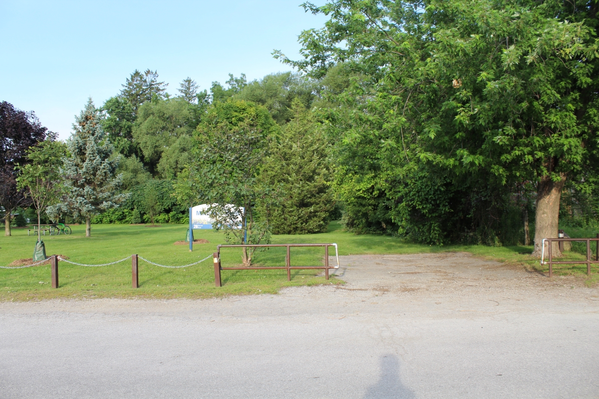
For example, on the left is a current photo of 28 Morrish Road in Highland Creek, Scarborough.
We can see a small field of mowed grass bordered by a low chain fence at the front and trees in the background. Hidden behind the trees
is a park sign and a bench. Located to the right is a driveway that leads into the grass. We also see a road for car traffic, with
and a notable lack of pedestrian and cycling infrastructure.
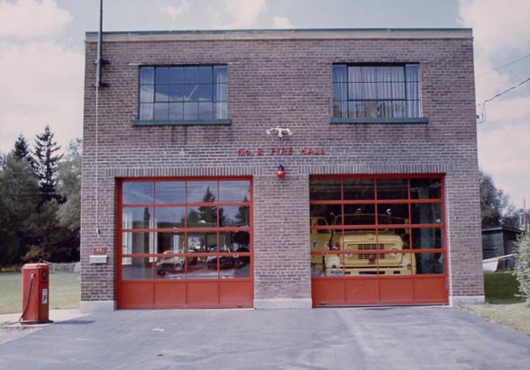
On the right is a photo from the same address circa 1979. We see the former Fire Hall No.2 building,
with a paved driveway leading to 2 red garage doors where vehicles are visible through the glass windows.
We also see a red tank/pump structure installed outside, with a few trees and a portion of another building
in the surrounding background area.
FAQ
Who built this site?
The site is currently being hosted by Nithursan Elamuhilan, a data analyst, photographer, and life-long Scarborough resident.
As one of the twenty Ontarians selected to be a part of the 2021 Ontario Community Changemakers co-hort,
this site is part of a project being supported by 880 Cities through their Ontario Community Changemakers Program. Learn more about the fellowship here.
A big thank you to OldTO for allow this to exist! The source code (the website's "blueprint"/code) was created, developed and made open source by Sidewalk Labs' members involved in the OldTO project.
That project was led by
Senior Software Engineer Dan Vanderkam (creator of OldNYC and
OldSF) and Associate Product Manager Matt Breuer, with
contributions from Jack Amadeo, Douwe Osinga, Sebastián Soto, Ryan Vilim and Alison Yard Medland.
Several members of the City of Toronto Archives staff provided critical guidance to the project during 2018 - 2020.
Where did these images come from?
The images for the initial launch of OldTO all come from the collection of historic city
photographs held at the
City of Toronto Archives.
The archives hold more than 1.7 million photographs dating
back to 1856, and more than 100,000 have been digitized and made available online.
The creators of itsneerby nor OldTO did not collect or digitize any of these images—credit for that
massive undertaking belongs entirely to the archives.
Currently, clicking on a photo pulls up the information contained in the description of the
archival holding, including (when available) the title, date, condition, and any copyright
restrictions.
Who holds the copyright for these images?
Copyright information for each image held by the City of Toronto Archives is shown with the image
entry. The archives gave digitization priority to images whose copyright is in the public domain,
which means permission is not required for reuse.
How did you map the images?
Building off the work done by OldTO, titles of the photographs in the archives were used to assign the image a
latitude and longitude—a process known as geocoding. For example, a photo titled “Yonge Street,
looking north from Temperance Street” would be geocoded to the corner of Yonge and Temperance.
Geocoding makes it possible to map the old images onto Toronto’s current street network, creating a
new way to explore the collection based on geography.
Geocoding isn’t perfect. Some of Toronto’s street numbers have changed over time—especially near the
waterfront, where land reclamation pushed the shore line into Lake Ontario. One example is a
1928 image
of a charming blockfront at “15 Bay Street”; today’s 15 Bay Street was nothing but green land
at that time.
It’s also possible that some addresses listed with the historic photographs were simply marked wrong.
If you see an incorrect address in the collection, please email us.
What else can this tool do?
In addition to the existing map of photographs plotted at their approximate location, courtesy of the OldTO engineering team,
an “aerial” button is also available to enable people to see how the city has changed from a bird’s-eye
view.
I’m a developer who loves Toronto. Can I build on this tool?
itsneerby wouldn't exist in its current form without having open data. The folks from OldTO had made the data for the project here:
images.geojson. This link will be updated with a newer data with more Scarborough Parks related information.
There are many creative uses of this data that you might think of, and
making the data open will help people come up with them.
As OldTO was an open-source tool, local urban-tech enthusiasts or civic
hackers can build on it or help improve it. The
source code for OldTO is available
on Github.
Is this tool connected to Sidewalk Toronto?
itsneerby is not directly connected with any plans from Sidewalk Labs, including Sidewalk Toronto - who have decided to cease their project in 2020.
What if I spot an error?
Oops... thanks for flagging that. The current geocoding process isn't perfect, and while refinements are being explored we can use some help in the meantime.
You can use the feedback button to contact us, or tweet/reach us at
hi@itsneerby.ca
or via social
media.